

The Stour Valley Path, a 60 mile route that follows the valley sides of the River Stour through the Suffolk, Essex and Cambridgeshire countryside.
Split into 10 sections of varying lengths, because 60 miles isn’t exactly a casual Sunday afternoon stroll.
With the Shotley challenge (if you’ve missed the news I’ve misguidedly signed up to walk 53 miles in 21 hours.) fast approaching we needed to crack on with some serious walking. Bored with the same routes of fens and Lodes my friend suggested the stour valley path and arranged us a lift home. Our aim to complete four sections.
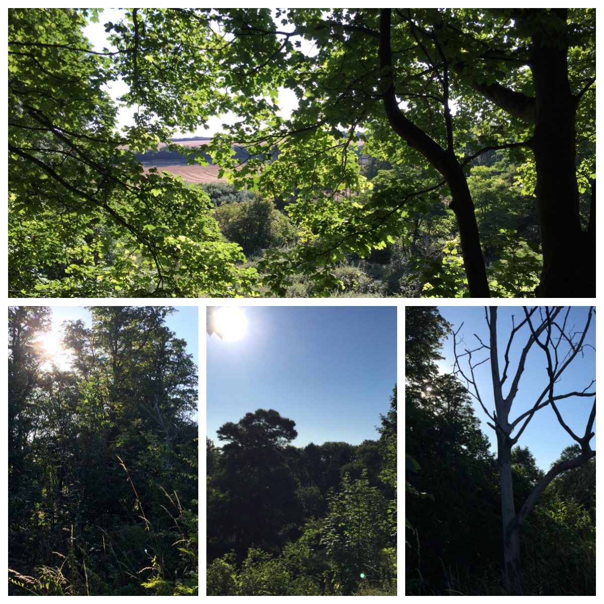
The path begins in Newmarket close to home and soon picks up the linear walk along Devil’s Dyke. We’ve walked the Dyke here countless times and it’s a bit dull. Instead we parked near Dullingham nearby where despite what the name suggests is really quite delightful. Lush green woodland lines the path and setting off early as the sun rose made the walk even more stunning.
Today I have a day off navigation.
No GPS. No maps. Oh-er!
My friend is armed with a walk guide for the route. The map very basic so we are hopeful the route is well marked.
We soon reach Stetchworth which signifies the end of the first leg. We are still in fairly familiar territory and the route is easy going. As we pass through the countryside, filled with woodland and Studs which dominate the area it looks like many of the places we have been before.
Hang on a minute.
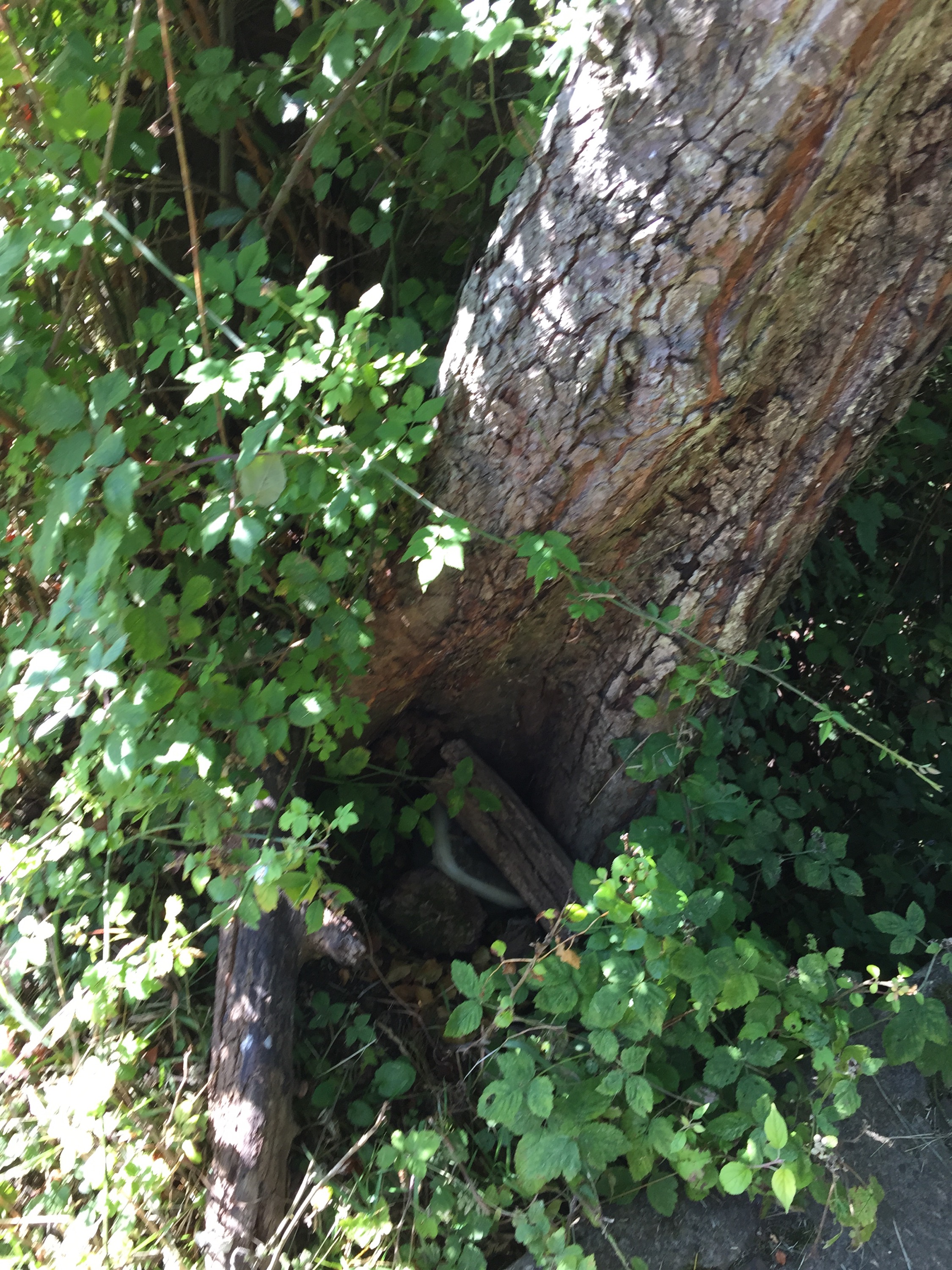
I spot a hollow tree which I’m pretty sure hides a geocache.
I have been here before. On Father’s Day.
I point out the tree to my friend.
‘Focus!’ Her sharp reply. That’s me told!
We follow the woodland track.
‘You know there’s a welly boot cache just in these trees?’ I casually point out.
‘Just shh!’
Humph
We finish the track in record time and cross a small bridge. Another cache I know is there, is exposed and laying there clear as day. I nod to its existence.
Guess who is asking to borrow a pen? I knew she’d crumble!
We cross the border to Suffolk. Hot on the trail of a runner. He’s marking a route. He asks if we are on a recce or walking. Off he pops again. Hmm…
Our paths crossing again several times. We ask what he’s up to. Next week A challenge run is being held on the path. Yep he’d assumed we were on a recce for a 60 mile challenge run. I like this man! 😉
We get distracted by a ford. (A soggy road, not a car.) Fords are cool! The benefit of this distraction allows running man to get ahead. From now on our way handily marked by fluorescent orange arrows. He just gets better! 😉
The first 10 miles are as ever, pretty easy going. My friend tracking our progress much to my amusement whooping as each mile is passed. We snack, we drink and invariably need to pee.
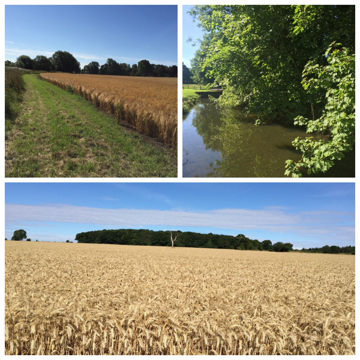
Miles 10-15. Much more psychologically gruelling. This seems to be the longest stretch of our journey. Now it’s lunchtime the sun is brutal. The day scorching. Most of our route across fields of crops with no way of escaping the heat and sun. We’ve also forgotten hats. Things just got tough.
It gets tougher. We reach a field with an ominous sign.

Our path crossing through the field. Holy flipping Cow bull!
We gingerly enter. We can’t see him.
Fresh pats all around suggest he’s about.
The field full of jumps and fences. What sort of evil, mutant bull is this.
Half ninja sneaking and half legging it through the field, my heart rate soaring.
Thankfully we clear the field without meeting the big fella. He’s probably much more sensible than us up and holed up in one of the few shady spots. We’d probably be sensible to join him!
Sadly running man has reached the end of his patch and we are now back at the mercy of the direction cards and signposts. Drat!
After the bull field we are left with the task of crossing the biggest fields of crops no doubt ever known to man. Miles of crops.
The woo of another miles progress stops.
It’s time to get our heads down, battle the miles and find some shade. Eventually the end in sight, the promise of a bridge meaning we are making progress. Our hopes however soon dashed by a sign proclaiming; ‘This is not the stour valley path.’
What?! Where did it go?
Clearly we aren’t the first in this predicament if such a sign exists. We double back. Multiple paths. No way markings for our route. Crap!
We choose the shady path. A small copse providing a brief respite from the heat. The nettles however are thriving and as we dance along the path to the stinging nettle shimmy it soon becomes clear the path is impenetrable. Double crap!
We can only head back. I’d spied a patch of random flattened nettles off to one side and realised that now it could be useful.
Hmm flattened nettles……a geotrail?
I turn on my geocaching app. Sure enough we are just 30 m away from a cache. Now is not the time though but thankfully the nettle bashing offers us an alternative track.
Following our new track, we reach a village.
Consulting the walk cards reaching a village is bad. Crappety crap.
Back we go once more to the corn field of hell. This time I spot a narrow adjacent track through the crops. Surely this has got to be it?
Thankfully we seem to be back on track. Extra mileage added to our walk in the gruelling heat. To the person responsible for moving the way marking sign here; I will hunt you down!
I will also promise to be much more organised with my GPS in future! And bring a hat! Oh and eat too!
Things pick up a little And so do our moods. Right until we round the corner and see a hill. Yep, our path goes up it!

We take a moment at the top to catch our breath take a photo and drink in the views.
Our route heading back towards villages and roads. The thought cheers me no end. So long fields of death!

Back in the relative safety of civilisation a special moment awaits.
We cross the border to Essex.
Essex! It takes ages to drive to Essex and I’ve just Bloody well walked here! Incredible! My mind well and truly blown. Go me!

We set a goal to make it to the village of Stoke by Clare. The route cards suggesting a pub. Let’s get to the pub!
Whilst only a few miles by road our winding cross country notching up our mileage ever more. We haven’t eaten in a long time. Once again we have failed in what is always our biggest mistake.

The scenery however is now much nicer, parkland and riverside views providing the necessary distraction we need to carry on. A field of cows to be crossed. They are plentiful and frisky little things, our determination to get to the pub however is no match for such flighty creatures.

Mile 19. I’m flagging. I need food. I can’t eat. It takes every effort to not vomit. As I stand at a junction in Stoke by Clare I haven’t felt so ill in a long time. Then finally the pub. We stagger in. (normally we stagger out 😉 )
I swear tumbleweed blows past and the good, the bad and the ugly plays. Not quite the quaint village pub we were expecting but at that moment I really couldn’t care less. All I can mutter at the landlord is still water. Lemon. Ice.
A quiet seat outside with my head between my knees. The water quickly downed. I’ve never wanted to eat less but I know the final stint to Clare without fuel will be doomed.
Beginning to feel a little more human we manage a fine lunch of sausage rolls and wine gums. Frazzles prove to be a rich dish too far! No more!
Patching up feet and changing socks it’s time to press on. The final destination tantalisingly close.

We are soon back trekking fields. Again we lose our path.
We come to the conclusion the farmer has ploughed it out.
Scanning the horizon I spot a gap in the hedgerow.
There’s only one thing for it. We too have to plough through it.
Crossing the roughly ploughed field with delicate feet is every bit as fun as you’d imagine.
I plod my way across. Slowly. I’m really pissed off.
My friend does what any good friend would do in the situation. She rushes to my aid She laughs and takes photos. 😉
Then finally a sign that this ordeal adventure is drawing to a close.
A sight for sore eyes feet! 
The last mile a pleasant walk which leads us to Clare country park. Clare a picturesque Town, a worthy destination. The huge sense of achievement that despite the harsh conditions we have reached our goal.
We’ve walked over 23 miles across three counties. My feet and legs feel like they have.
The sobering thought though that in a short while we need to walk this far and another 30 miles on top. Right now this seems an unachievable nightmare dream. My usual stubbornness and determination suddenly don’t quite seem enough.
There’s only one thing for it. To spend the next few weeks walking everywhere.
Well, once my feet have stopped hurting anyway!


Oh my… I feel exhausted at the thought. Here I am moaning about moving a few piles of logs this morning and then I read this! Extremely well done. 🙂
LikeLiked by 1 person
But I need to do so much more!
Argh!
LikeLiked by 1 person
Way to go! I was cheering for you all the way, except when I was laughing. lol
LikeLiked by 1 person
Such a delightful day.
No sarcasm whatsoever! 😉
LikeLiked by 1 person
A great name indeed! You are like superwoman, but how could you walk that far and turn the GPS off – will power indeed! In other news we converted our 19 yo to geocaching on Sunday – she loved it – addicted, she has taken this Sunday off to do it again ha! X
LikeLiked by 1 person
That’s brilliant! Another convert 🙂
I’m not feel very super woman today, more like old woman!
LikeLiked by 2 people
Awww!! Maybe that’s the sausage roll taking its revenge 😉 x
LikeLiked by 1 person
That is some feat! S’cuse the pun haha. Oh my goodness I bow down to you, I start to get bored with walking after about 3 miles. I thought I was the only person who says crappety crap, well I go one further and usually say crappety crip crap. Very brave to go through the bull field, I would definitely have given up at that point.
LikeLike
Ha! Great pun! There are some occasions when only a crappety crap will do!
Had I have seen the Bull I think the crip crap would have been very useful. I’ll try to remember that one next time I’m being chased through a field! 😉
LikeLiked by 2 people
Oh my goodness, very well done. I lived in Haverhill (junior reporter at the Haverhill Echo) so seeing the sign brought back memories.
LikeLike
Thanks. I couldn’t believe it when we near Haverhill – it takes ages to drive there! Well, even longer to walk there…😉
LikeLiked by 1 person
Beautiful photos of the countryside and YES a perfect name for a town! Hope your feet feel better soon!
LikeLiked by 1 person
I did take a selfie with the Clare sign but quite honestly I looked shocking! Blisters are fine but I seem to have picked up some kind of muscular injury in one foot. Hobbling like a peg leg pirate tonight! Nooooo!
LikeLiked by 1 person
Wow this was so nostalgic for me, my grandmother lived near Stetchworth and we often went to Clare and Dullingham! Congrats on the walk, I am very impressed indeed!!! xxx
LikeLike
Oh wow! It’s a very lovely area – thankfully without too many hills! 😉
LikeLike
Yes the lack of hills is definitely an advantage, that and seeing horses – our local stud used to let us wander around and pet these amazing race winning animals!
LikeLiked by 1 person
Yep I love the horses – when they behind a fence! Ha!
LikeLike
Yes one bit me once and I have to admit to being a bit more tentative around them now!
LikeLike
We did the 40 mile Ridgeway challenge a couple of years running but I don’t intend to do it again 🙂 At least the navigation on our route was simple, sounds like the farmers aren’t too keen on walkers in your area, what with bulls, frisky youngsters and ploughed paths! Good luck with the rest of the training.
LikeLiked by 1 person
Oh my life! Running?! Respect! I think I could manage 40 miles (walking) but 53 could well be the challenge that defeats me.
LikeLike
I am tired just reading this! Wow girl! I just want to hit the 30.000 steps mark on my fit bit! 20+ miles in a day!!! You go girl!
LikeLiked by 1 person
I’ve been injured ever since though! Twisted my foot the following day – I’m a broken woman! 😩
LikeLike